
Where Nature Dazzles with Mystery
Patagonia is a world that is both closed and open at the same time, a place that astonishes all who come into contact with it. Although there are no exact limits, the region occupies an enormous area at the southern tip of South America in between Chile and Argentina, encompassing both the southernmost area of the Andes Mountains and the vast eastern plains that extend to the Atlantic Ocean.
In Chile, the Patagonia includes the strip of the Andes Mountains that touches upon the Araucanía and Lake regions, as well as the entire area of Aisén and Magallanes. In Argentina, the area includes the provinces of Neuquén, Río Negro, Chubut and Santa Cruz.
Although the landmass comprising Patagonia is very extensive, most experts agree that the region is basically comprised of two large geographic areas: the pampas zone and the Patagonia Andes. Both areas overlap in countless ways; the pampas is a territory dominated by seemingly endless flatlands and plains with abundant but nearly imperceptible vegetation; while the Patagonian Andes, majestic in its capricious form, appears to compete with the sky and clouds.
The Patagonian Andes include the tallest peaks in the region as well as the famous Patagonian glaciers, which are nestled along the mountain range and reach out like large tongues into lakes and fiords.
History
The Portuguese navigator Fernando de Magallanes led the first European expedition that managed to reach these regions located at the end of the world. This dangerous mission lasted a total of 3 years, between 1519 and 1522. Five ships set out under the leadership of Magallanes, but only one –the Victoria –reached its destination, achieving the first global crossing in history.
Magallanes never managed to return to Spain, since he was assassinated just before finishing his mission in 1521 in Mactan. Efforts by the explorer contracted by the Spanish crown were memorialized for the sake of posterity with the name given to the straits where the expedition discovered the route toward the Pacific Ocean.
Crossing these waters was slow and arduous, something never accomplished before by Europeans. Five weeks were needed just to complete the trip across the straits. Despite this, the expedition had a significant impact upon the way the world was understood. As a result of this expedition, the Spanish crown granted itself territorial rights over the New World.
Well before the arrival of the Europeans, Patagonia was the home of various ethnic groups, who all seemed an unfathomable mystery to the first settlers.
Among the indigenous groups of the region are the Tehuelches, whose population was annihilated a short time after the Europeans first arrived. The Tehuelches included the Gununa’kena people in the northern region, the Mecharnuekenk tribe in the southern and central Patagonian regions and the Aonikenk or southern Tehuelches in the southernmost part of the area just north of the Magallanes Strait. On the Great Island of Tierra del Fuego, the Selk’nam (Ona) and Haush (Mannekenk) lived in the northern and southeastern parts, respectively. The Yámana tribe lived on the archipelago south of Tierra del Fuego, and the Kawéskar (Alakaluf) resided on the islands and the western coast of Tierra del Fuego.
The first encounters between Europeans and Patagonia’s native inhabitants did not prove to be very encouraging. With the exception of a few scholars such as the priest Martín Gusinde, who wrote extensively about the Selk’nam culture, the colonialists never really understood the natives.
During the last decades of the 19th century, many European expeditions brought groups of men and women from Patagonia to exhibit them on the old Continent as part of a circus.
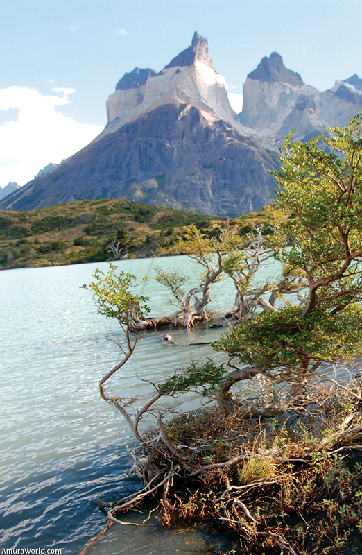
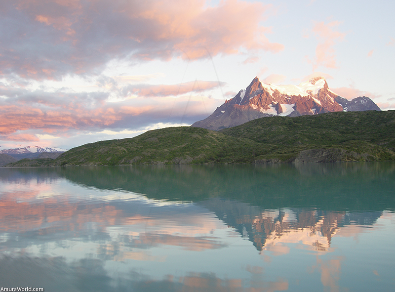
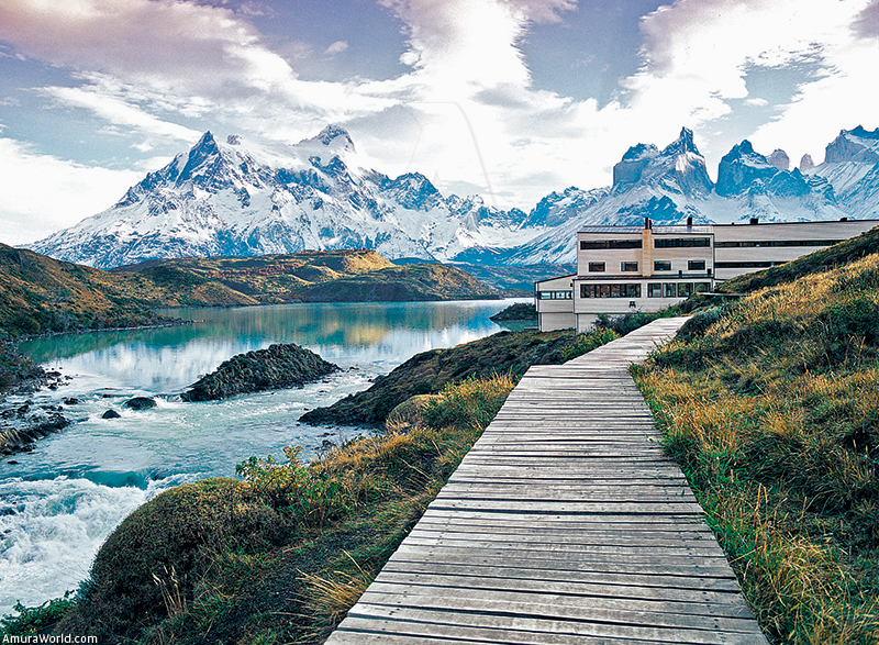
Torres del Paine
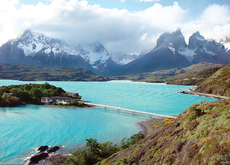
The Torres del Paine national park is located in the heart of the Chilean Patagonia, 400 km north of the city of Punta Arenas. The total land area of the park is 242.242 hectares and is located on the southern hemisphere of the planet: 51° 07’ south and 7° 10’ west.
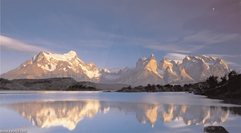
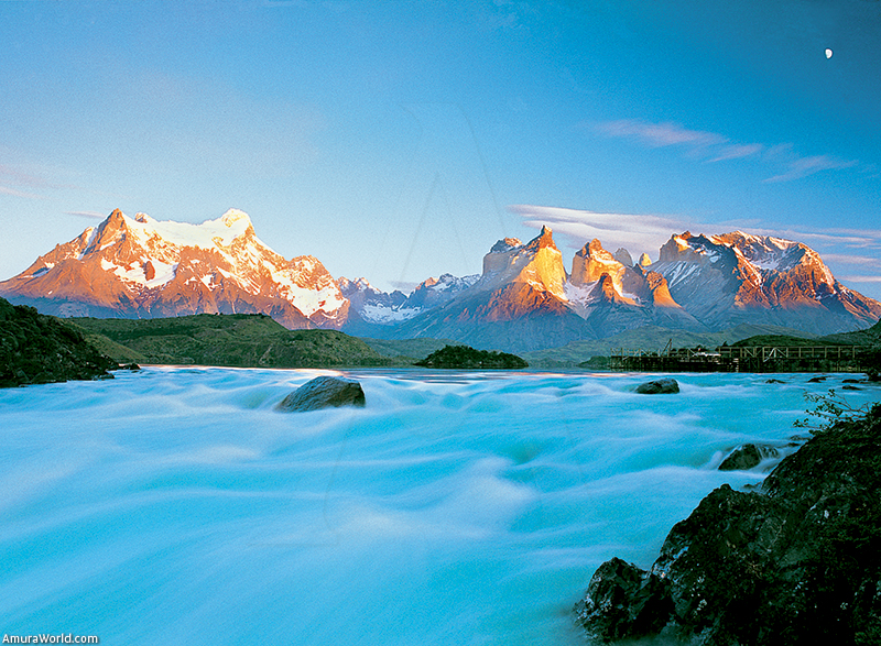
With mountains and granite peaks, glaciers, lakes and cascades, in addition to being home to unique species of flora and fauna, this park is considered one of the most beautiful in the world. In 1979 it was designated a World Heritage site by the UNESCO. The Patagonian landscape is in general the result of two great natural phenomena: tectonic forces and glaciations. The great mountain range of the Patagonian Andes came about as the result of constant pushing from the west caused by the Nazca and Antarctic oceanic plaques. This occurred while the corrosive effects of the planet’s many glaciations sculpted cavities that gave rise to the accumulation of the region’s archipelagos, fiords and canals.
Glaciers
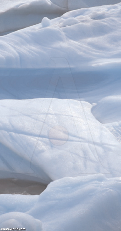
The erosive force of the glaciers is evident in every detail of the Patagonian landscape. If observed carefully, one can appreciate the many furrows and striated surface areas that cover the exterior of the granite peaks. These “scratches” are the product of the glacier’s erosive effects that have modified the region’s geography since many millions of years ago.
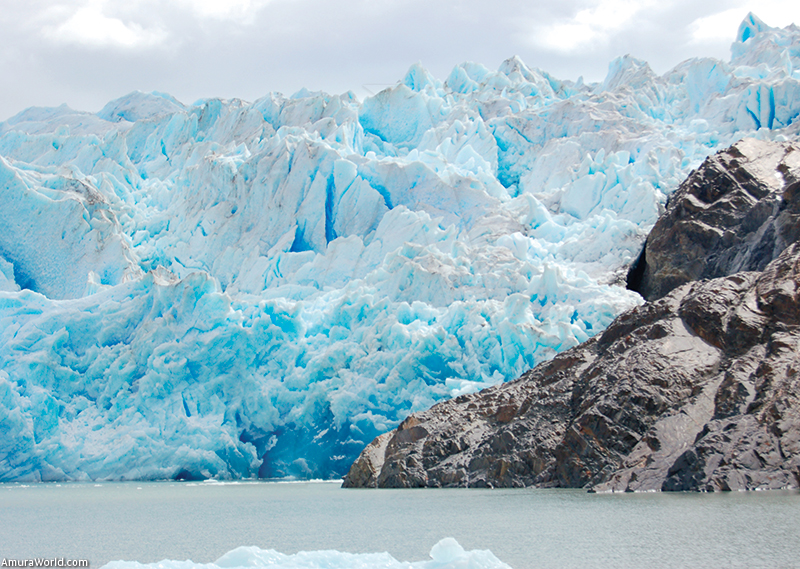
The local glaciers in the park are of an Alpine type or “snowdrift”, characterized by its form of an arm or ice lobe embedded in a rock-walled valley. Within the park, the most typical glaciers are Grey, Tyndal and Dickson. They all come from the great glacier cap that comprises the ice field of southern Patagonia, the largest in South America.
The glaciers are natural phenomena in a state of constant activity. The sleet and rain in the icy country highlands constantly feed the great glacier that simultaneously feeds the many snowdrifts that descend from both slopes of the Patagonian Andes. The rocks that make up the walls and depths of the glacier valleys are polished and striated, testimony of constant glacier movement.
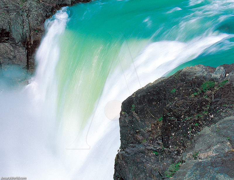
Nowadays, a lake whose water comes from the melting of the glacier that gives rise to it occupies most of the glacier valleys. The spectacle created by these phenomena is impressive. The abrupt meeting point between the ice and water is in itself one of the most beautiful scenes of this fascinating region.
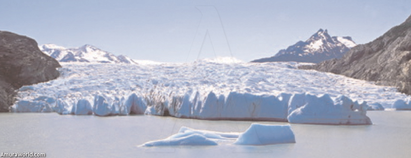
The glacier adopts vertical, pointed shapes and, thanks to the effect produced by the reflection of light, the ice appears to be a blue color, ranging from a light and nearly transparent blue to a deep blue color in the most solid and densest areas. In the lake produced by the glacier ice melting, one may observe an assortment of ice chunks sculpted in many diverse shapes with vertical lines and some circles. These natural sculptures lie in the water and may be admired by passersby. The icy water produced by the glacier has an intense color, nearly milky, as a result of the sediment that rushes in upon the flow. During the periods of greatest ice melt, there is an increase in the quantity of sediment that flows from the glacier toward the lakes, so that in some cases the murky water drastically changes color during the year. This is what is commonly referred to as glacial milk.
The glaciers are not made solely of ice but transport along their surfaces many rock formations. The rocks encrusted in the glacier also contribute to the erosion of the valleys during the glacier movements. When the glacier is fed more than it melts, growth or advance results. If the opposite occurs, the result is diminution or retreat. It is also possible that a glacier begins to flow purely as a result of gravitational effect. Most of Patagonia’s glaciers have registered backward movement during the last one hundred years. Among the exceptions is the glacier of Perito Moreno in the locale of El Calafate in Argentina. Glacier science studies permitted the measure of its advance, nearly 2 meters per day.
Geological Profiles
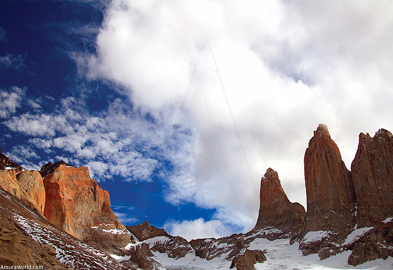
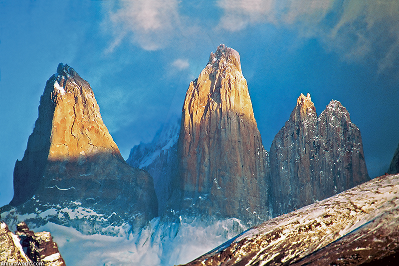
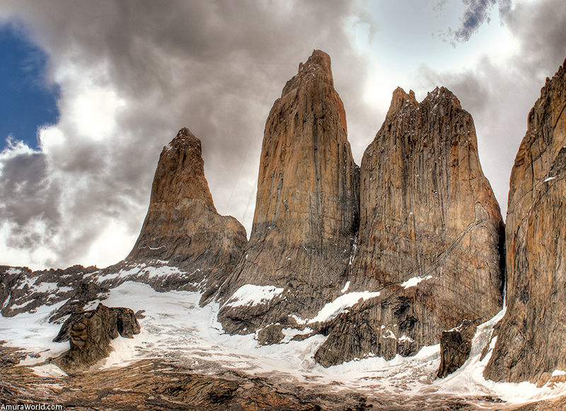
The landscape of Torres del Paine is dominated by formations – unique in their beauty – of rocks of great heights, like the mythic towers to whom they owe their name.
The geological processes that carry the construction and modeling of these imposing structures have their origin in the erosive effects of the glaciers, but also correspond to other type of natural phenomena. A great part of the mountainous area of Torres del Paine – a complex of peaks separated by glacial valleys – is taken up by intrusive granite mass. This is a whitish colored rocky body that 12 million years ago was injected as magma between layers of dark brown rocks belonging to the formation called Bull Mountain. The thickness of this granite body reaches nearly 2,000 meters and is identified in the section located between the French river valley and the mountain of Admiral Nieto. The contrasts in color produced by the types of rock make these peaks a very special sight.
Another of the most imposing rocky formations in the park may be appreciated by an excursion on foot up to the base of the towers. This hike lasts about 6 hours and most of the tour is comprised of moderate to steep slopes. The last part of the outing is the most demanding, as it requires climbing a series of rocks deposited by the glacier many years ago known as Morrena. If you do not have health problems, are traveling with a guide, and have lots of energy and adequate equipment, it’s worth making an effort to reach the base; your reward shall be an unrivaled view of the surrounding area.
Where to stay
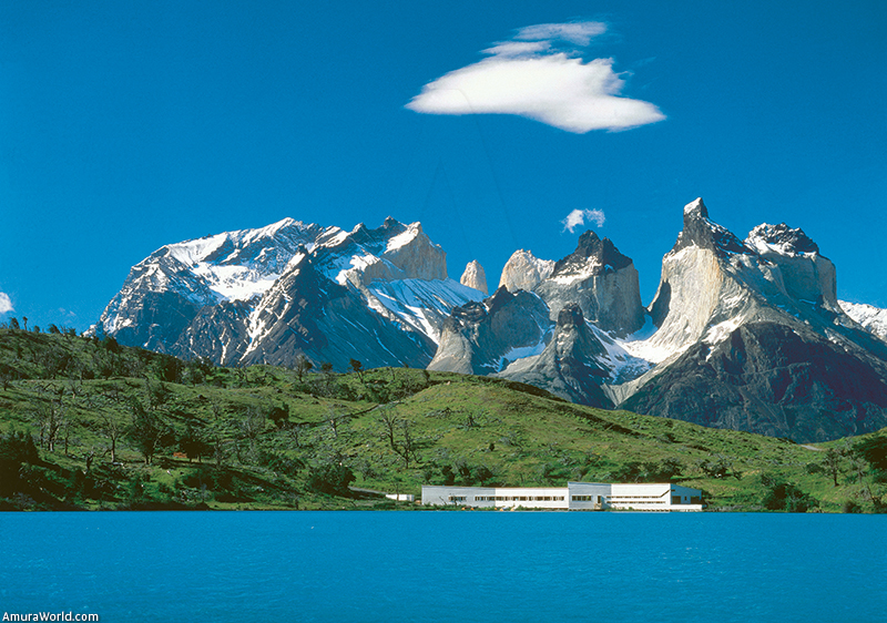
The best way to explore Torres del Paine is from the comfort of a hotel. Being a national park, only a few constructions are permitted in this area; nonetheless, a luxury hotel option exists within the park. This is the Hotel Explora, part of one of the most prestigious hotel chains in Chile. The Hotel Explora in Patagonia has an unbeatable location within the Park and features luxurious and discreet installations that permit a comfortable exploration of the region.
Climate
Torres del Paine is located in the southern hemisphere, which means that the seasons are the opposite of our own.
The park has a microclimate influenced by its proximity to the sea, meaning that temperatures are generally pleasant both in winter and summer months. During the rainy season, precipitation rarely exceeds 80 mm.
Wind is a major factor in the weather at Torres del Paine. Winds up to 70 knots has been registered in this zone. In general, the winds produce weather that may change unexpectedly. It is not unusual to have rain that within a short time dissipates and leaves behind bright sunlight and clear skies.
The winds mainly blow in toward a westerly direction and generally are more frequent at the end of spring and beginning of summer. There is practically no wind during the winter months and, with the exception of a few isolated storms, this season features a handful of sunny days.
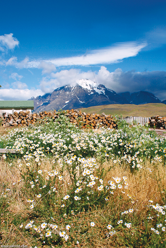
The rains are relatively moderate, while during the winter months the snow falls mainly in the most elevated regions in the park. In the zone of the lakes, there snow falls only a few weeks during the year. During the winter months (June and July), the temperature oscillates between 2 °C and 13 °C. In the summer (January and February) the maximum temperature is 24 °C and the minimum is 12 °C. In the spring (September and October), high temperatures of 19 °C have been recorded, whereas the low temperatures are about 4.5 °C. And in fall, the landscape is especially beautiful, as the trees change in color and turn to red and orange shades. The temperatures at this time vary between 22 and 5 °C.
What to take
In order to explore the park, it is best to take a thermal sweater and another that is both waterproof and wind resistant; a comfortable pair of water resistant hiking pants; and walking boots with protection for the ankles. For flat walks, it is recommended to take shoes with anti-slip plastic heels and preferably water-resistant. It is also recommended to take gloves, hats, sunglasses, sun protection and blocker, lip protection and insect repellant.
Money
The official currency is the Chilean Peso, whose symbol is CLP. Each peso is divided into 100 centavos. The exchange rate is 41.2 Chilean pesos for 1 Mexican peso.
How to arrive
LAN flies directly from Mexico City to Santiago. From Santiago you may board a direct flight with LAN to Punta Arenas. The 5 hours trip from Punta Arenas to Torres del Paine may be made either by car or public transportation.
Documentation
Mexican citizens do not require visa to travel to Chile but visitors are required to pay a fee of 15 U.S. dollars upon arriving in Chilean territory. This fee is paid at designated windows at the airport in Chile. A valid passport is required that is valid for at least six months from the trip start date.
Text: KundaliniMuñoz ± Photo: Flickr.com, Explora Chile ,Margarida Luz.