
Chilean coasts: fromPichilemu to Zapallar
The Chilean coasts offer surprises and fascinating contrasts with beautiful and wild bays. Chile extends from the Tropic of Capricorn to Patagonia, with a wide variety of climates and landscapes. On this trip, we wanted to visit two of the country’s most unusual landscapes: Easter Island and the Central Coast, from Pichilemu to Zapallar, a voyage that includes Vina del Mar and Valparaiso.
Easter Island or Rapa Nui
Located in the middle of the Pacific, Easter Island is the most isolated island on the planet. The closest Island, Pitcairn, is 1,900 km away and was colonized and is still inhabited by the descendents of the mutineers of the Bounty, who were deported to the island. The Mangarevas Islands, part of the Polynesian Archipelago, are 2,500 km distant and the Marquesas Islands are 3,200 km away.
The coast of Chile, the country to which Rapa Nui belongs, is 3,7 00 km away and the LanChile aircraft that took us there took five hours from Santiago, a trip that would have taken long days of sailing. On arrival, we rented a small launch to tour the surprising coastline of this volcanic island.
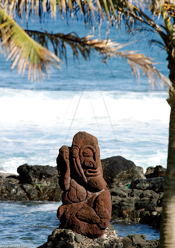
Rapa Nui is 24 km long and 12 km wide and is formed from the lava of three volcanic cones: Terevaka, to the north, with a height of 652 meters, Pukatiki, to the east, with a height of 400 meters that forms the Poike Peninsula and Ranau Kau, to the southwest, with a height of 410 meters. Small craters can be found all over the island, such as Rano Raraku, where men carved the Moai stone statues, and Puna Pau, where the hats (pukao) of the Moai were carved. The island rests on a marine platform some 50 to 60 meters below the surface of the sea, which terminates at a distance of 15 to 30 km where the ocean floor drops from 1,800 to 3,600 meters in depth.
Rapa Nui is enigmatic for its culture where Latin American and Polynesian traditions are mixed. The history of how the first settlers arrived on this remote island and how they survived on a piece of land covering a mere 117 km? has never been revealed. What is certain is that they came from Polynesia, from the Marquesas Islands and they would have to have sailed for months on end in very small boats.
How they survived that long voyage, taken by the currents, has never been explained. Once settled, they said about carving colossal figures, the Moai, extracting them from the volcanic rock and transporting them using a system of trunks to the coast where they were erected on stone platforms known as “ahu”.
The legends of Rapa Nui tell their version of history, but we will never really know the truth. The legends tell that “shorteared" men arrived from the west and “longeared" men from the east, which could mean that they also arrived from Peru. Norwegian scientist Thor Heyerdahl set about to prove this theory in 1955 with his Kon Tiki expedition, a vessel made from balsa wood and hemp that grows around Lake Titicaca.
According to spoken legend. Hotu Matua was the first to arrive in about 450 A.D. the people concentrated on growing crops and constructing the moai. which serve as a reminder of the most illustrious ancestors. Ceremonies were held in the sacred place, the inhabitants lived in small boat shaped oval stone houses, called hare paenga.
The island was so prosperous that it is calculated that in the 10th century it had as many as 10,000 inhabitants. Civil wars killed off the “short eared” population, the population decreased, the trees had disappeared and the moai had fallen down.
The new age forgot the cult of the moai and dedicated itself to the culture of birds. The people awaited the arrival of migratory birds, which according to spoken legend, was sent by the god Make Make. The birdman ceremony consisted of a competition in which the representative of each of the tribes, with their bodies painted climbed down the cliffs of the Rano Kau volcano to swim towards the Motu Nui islets, some two kilometers away in order to steal one of the eggs of the Manutara bird. They returned to deliver the egg to their ariki (King) who turned them into Tangata Manu, the religious and political chief of the island for a year.
The Dutch expedition led by Jacob Roggeveen arrived in April 1722 and called it Easter Island, to mark the day on which they discovered it It was visited by the English explorer James Cook, the Spaniard González y Aedo and the Frenchman Jean Francois de la Galaup, Count of la Pérouse. But by the 19th century, the island was in complete decay, the European expeditions had kidnapped more than 4,000 islanders to send them to work in the mines of southern Peru. The Catholic religion had brought total confusion, the last election of Tangata Manu was held in 1866 and in 1888, Rapa Nui became part of Chilean territory.
The first thing that surprises on arriving on the island is its relief, which is composed of various volcanoes and the entire coast is characterized by black rocks, caves, sandy beaches and small coves.
The LanChile aircraft landed on the short runway that crosses the island at the foot of the Rano Kau volcano and shortly afterwards we found ourselves in the capital. Hanga Roa. We were installed in the Ranga Roa Hotel, which dominates the city and the sea. where the waves slam against the island lost in the huge ocean.
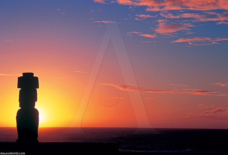
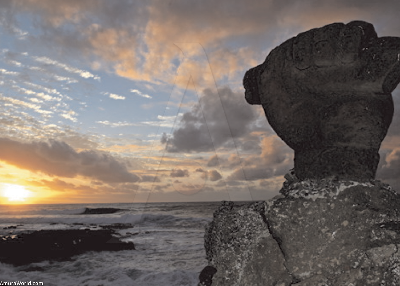
In the Hanga Roa marina, dominated by one of the moai. we found our small boat ready to resist the force of the sea. The town was very quiet, forgotten in time and inviting us to observe one of the most spectacular sunsets on the side of Ahuakapu, where the sun illuminates the moai that standout on the horizon, filling the moment with magic.
According to tradition, people believe that the souls of the dead rose up to the sky and flew towards the horizon to be lost. The moai were erected on the “ahu" platforms facing the center of the island with their backs to the sea in order to protect the island from the evil spirits of the souls and. according to legend, to allow the souls to return to the island without getting lost.
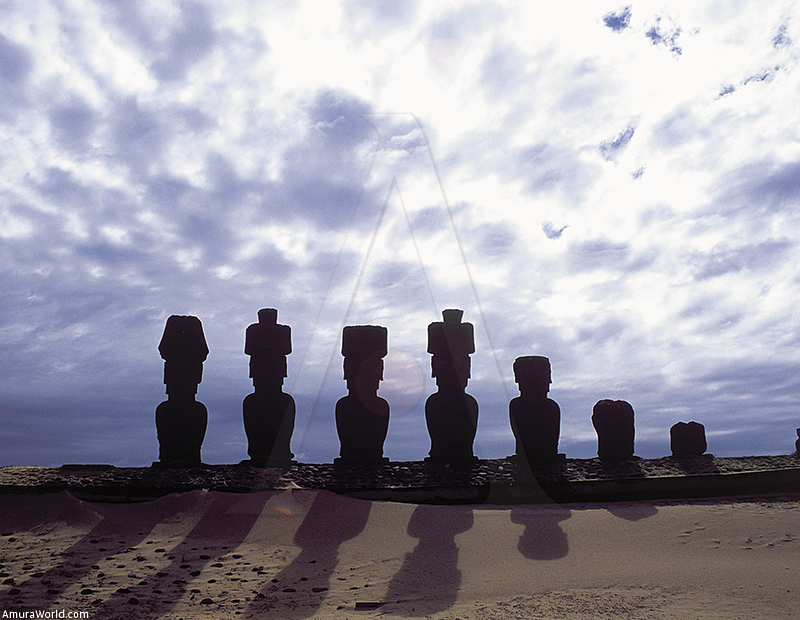
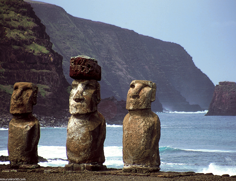
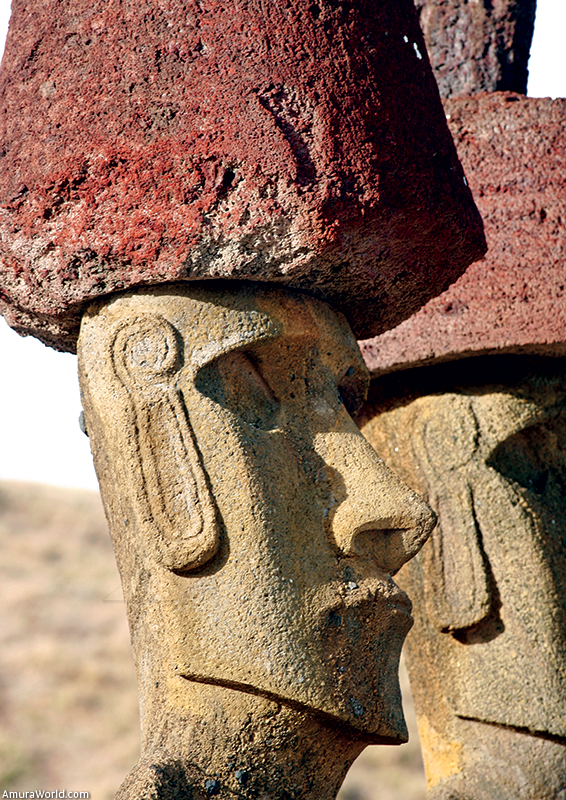
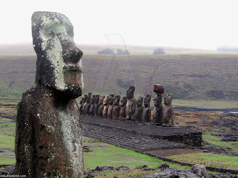
On average, these monoliths measure between 5 and 7 meters tall and the tallest is 21 meters tall, although it was never finished. Each moai has different features and most of them have a pukao, a stone hat placed on top of the figure once it was carved.
300 moai, 250 ahu and various hare paenga have been found, which can accommodate up to 100 people. The ahu are distributed along the coast and Ahu Akivi is the only sacred place inland where the moai face the sea.
We started on voyage towards the north along the coast with small and high cliffs of black stone, sharp, pounded by the waves, with very little possibility of putting in. It is a very inhospitable coast that offers an unusual and sober landscape guarded by the moai.
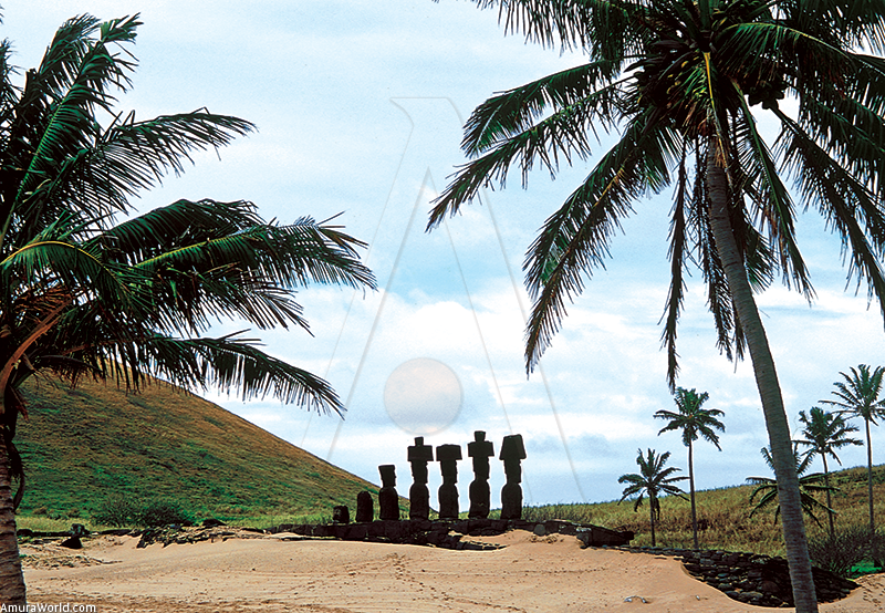
We crossed several of these places full of mysticism and we followed the coastline broken by the MaungaTerevaka volcano until we arrived at the small Bay of Bahia de Anakena. where we were able to put into the white sandy beach edged by coconut palms, where we camped. We saw the moai that guard the ocean and we visited the sites of Hanga Otfo. The feeling was one of being in a place inhabited by the ghosts that surround these figures that defied time.
The next day we went to see the beautiful Ovahe beach, the sites at Te Pito Kura with their ahu and to find a small protected port in Hanga Hoonu to visit the sacred places. We sailed the coast of the high cliffs that edge the Poike volcano until we reached in slightly more protected south coast, with its calm sea to moor in the small cove of Tongariki. Then the beautiful site of Hanga Tu Hata appeared where the moai rise up at the sea’s edge, within a great religious site.
We took advantage to visit the Rano Raraku volcano, the site of the quarries where the moai were carved and where we found many unfinished statues and in the volcano’s crater, a lagoon that holds the island’s drinking water.
The last leg of our took us to discover the South Coast, with its small coves and its wide variety of ahu. and finally to the foot of the Rano Kau volcano, which contains another lagoon, with Orongo and its elliptical houses on the edge, with impressive cliffs that form a natural barrier against the sea. This is where the islets or motu (Kau Kau. ltd. Nui) can be found, where the birdman found the symbolic egg. Finally, we arrived at Hanga Roa, delighted to have seen one of the Earth’s treasures. More surprises awaited us when we dived to discover the marine depths, such as multicolored fish, rays and sharks.
Easter Island is one of the most unusual places in the world, which charms, surprises and conquers for its history, the moai and the gentleness of its people, whether music has Polynesian rhythms with lyrics in Spanish.
From Pichilemu to Zapallar
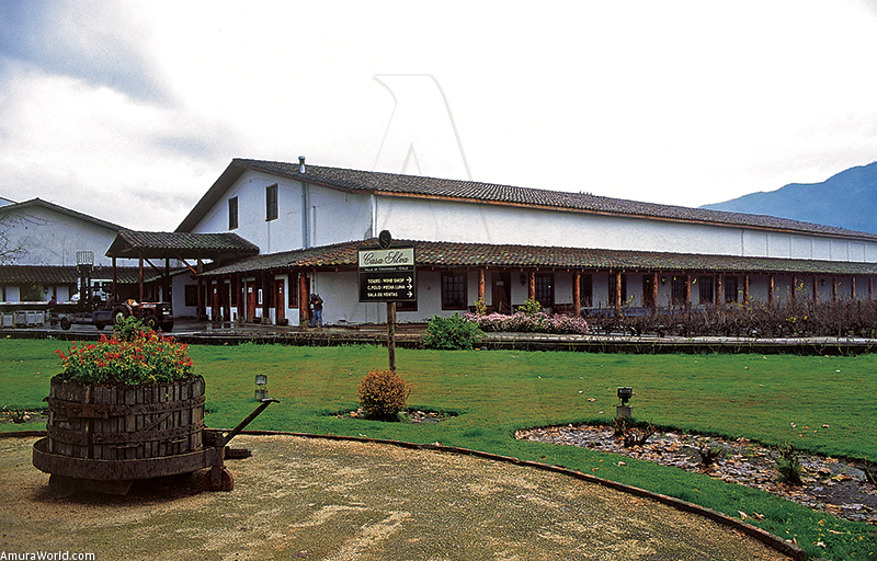
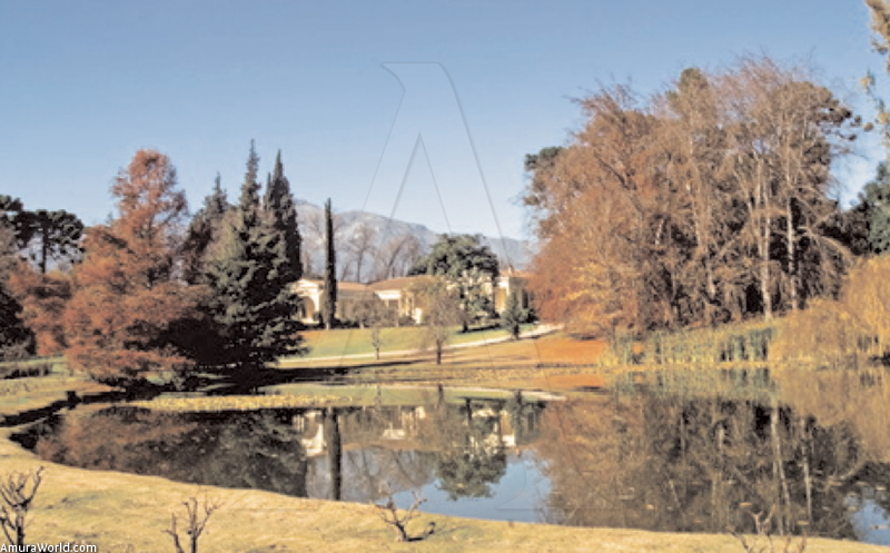
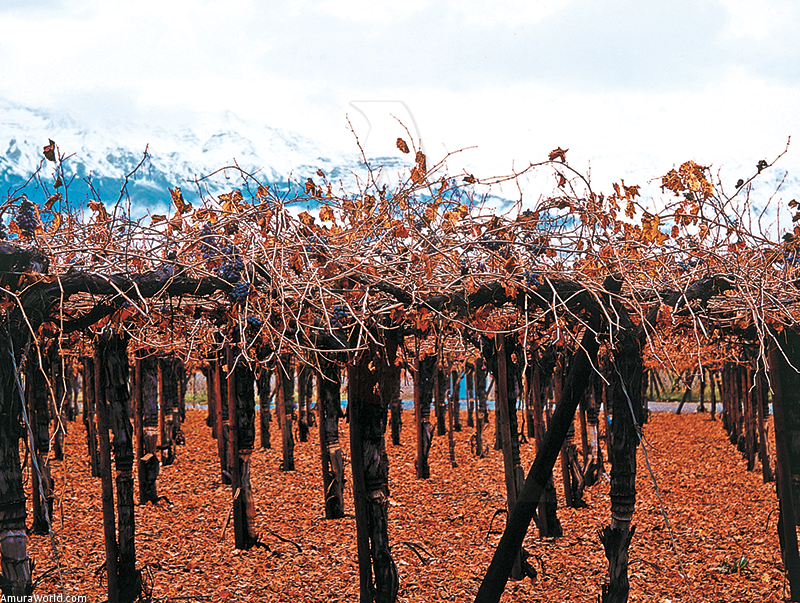
On returning to Santiago on a LanChile flight, we visited the best vineyards in the region of the foot of the Andes, whose peaks are covered in snow, hidden in the valleys of Maipo, Casablanca. Totihue. Cachapoal. Colchagua and Maria Pinto.
The wineries produce wines of world renown, such as Concha y Tbro. Casa Silva. Altair. Undurraga. Cousifto MacuL Santa Carolina and Santa Rita. The wine tasting routes took us to discover these charming valleys to taste the best wines with the greatest flavor, as well as enjoying beautiful rural scenery.
One venturing into the Andes, we found surprising streams with waterfalls, where the snow meets cactus, the cows produce milk for the cheese factory and the highways lead to skiing stations such as Portillo and El Colorado. El Cajón del Maipo is a natural treasure at the port to Santiago which we visited during a snowfall that created an exceptional scene.
After crossing the Rancagua Valley, we reached the port of Pichilemu, with its long beach, which seems the remotest place on Earth where fishermen rule.
The climate is not very pleasant, but the small fishing boat was ready to face the sea. We sailed along the coast of large beaches and cliffs and saw seals which defied the waves from their rocky lookouts. The great rivers flowed into lagoons bursting from recent rains and the sea took on the color of the land from these torrents.
We reached San Antonio, with its excellent harbor protected by gorges that enclose the bay. San Antonio suffered a tsunami that destroyed a large part of the coastline in the early 1960s. Signs were erected to indicate the location of refuges in the event of another such phenomenon. It is an extraordinary fishing port where life is focused on the sea.
Following the coast, we admired beautiful beaches surrounded by pine forests. We stopped off at Isla Negra to visit the house of Pablo Neruda, the great poet who lived for many years in this coastal paradise. We reached the charming towns of El Tabo. El Quisco and Agarrobo.
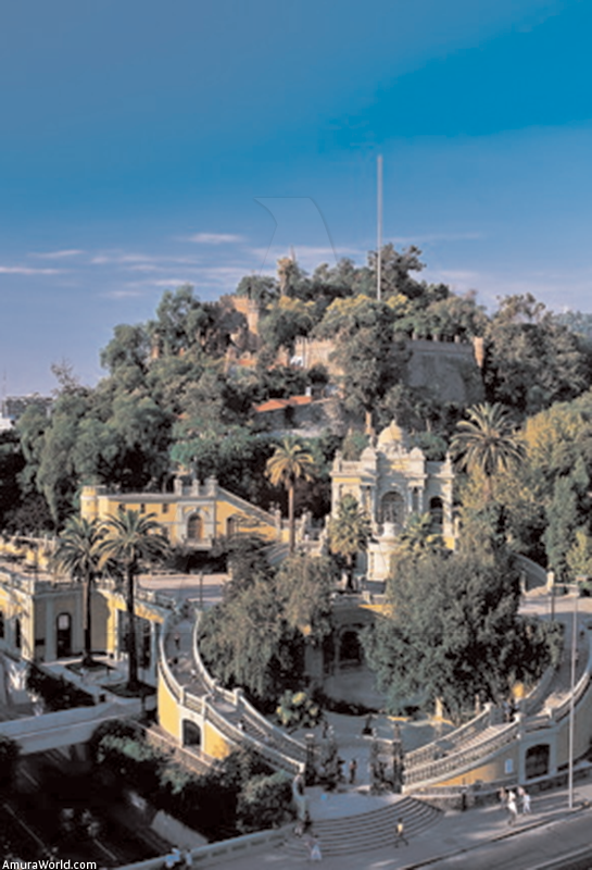
After sailing along the wildest coast, edge by impressive cliffs, we arrived at Valparaiso, Chile’s great commercial port, where we received by its European atmosphere and funicular railways up to the hills. The beautiful buildings bear witness to the importance and the wealth of the city and from the hill the view is spectacular.
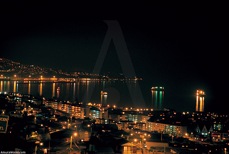
We visited the elegant summer city of Vifta del Mar. with its long beach that spoils sun and sea lovers. Among its highlights are its fabulous buildings, large mansions, haute cuisine restaurants and excellent seafood, the Sheraton Miramar Hotel and an enjoyable nightlife that reaches its peak during the summer.
The last leg of our voyage took as north along the coast dotted with mansions, small ports, long beaches and hill is that seem to run into the sea and dotted with islets.
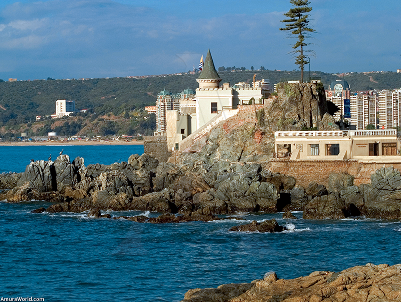
Concon sits atop a green hill, while Quintero and Punchuncavi have long beaches. A large wooded hill protects the town of Zapallar. tucked into one of the most beautiful bays on the coast The elegant mansions are hidden in the forest and in
the middle of this breathtaking scenery, we stayed in the Isla Seca Hotel to rest from the tough journey.
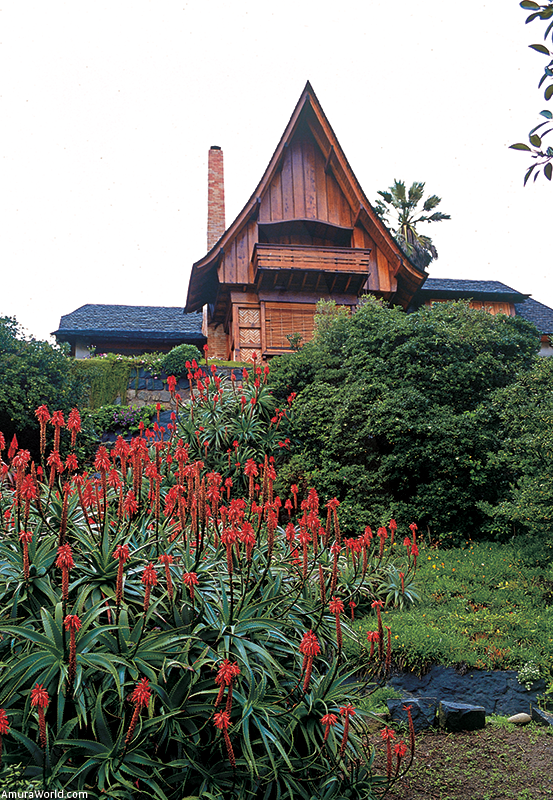
Zapallar is the most distinguished town along the coast, where the Santiago jet set lives in large mansions amidst charming pines.
If Vifla del Mar is the city of bars, discos and fun. Zapallar is the city of elegance and peace and quiet
Following the exhausting journey, although full of fabulous views and charming towns, we reached the Andes, crossing the San Felipe Valley with its vineyards. Then we went up to Portillo. Chile’s best ski station, which enjoys a long winter season from June through September with the best ski runs and an exquisite winter ambience.
Chile is a surprising country that seduces visitors with its wide variety of scenery. Our trip has been varied, from Easter Island, one of the most intriguing places on the planet, to the wild and elegant coast of the Santiago area, passing through the region of the best vineyards, watched over by the snow topped Andes. From the beach to the ski runs, we enjoyed a wide variety of climate and scenery, enjoying the best food, excellent seafood and fine wines.
Rapa Nui is the mystery that conserves the treasures of its history guided within its black rock slammed by the waves and watched over by the moai. Chile is a land of surprises, where the way of the people is as magnificent as the beauty of its landscapes.
Hotels with Great Charm
Sailing through the coasts of Chile implies discovering places with great charm, where a good wine and the refined food go with the pleasures of the trip.
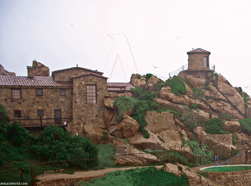
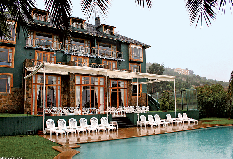
In the Isla Seca Hotel from the magnificent village of Zapallar. you can admire one of the most beautiful views of the coast and in Cala you can enjoy the refined author’s kitchen.
From the other side of the sea. in the Island of Pascua, the Ranga Roa Hotel allows you to enjoy the spectacular view from each bungalow. With regional cuisine in the restaurant Kona Kai, mixes the Chilean with the Polynesian flavors. It is a magnificent place in the unusual territory of Rapa Nui.
In exceptional places, these hotels with great charm invite the travelers to live exquisiteness, either for the big vintages, the dishes or the landscaping and comforts. Chile knows how to pamper its visitors.
The main attractions of Zapallar are its spectacular beach of white sands, the pedestrian walks at Cerro de la Cruz, watch the sunset in the Mar Bravo, the Paruqe de la Paz, to visit the cove of fishermen, to climb crag of Isla Seca. travel through their streets knowing the stately houses and precious gardens that conform the spa. Also you can climb the Boldo Hill and to enjoy a spectacular view of all the Zapallarina bay and its outskirts.
Info
Hotel Isla Seca
Zapallar
T (56-33) 74 12 24
This email address is being protected from spambots. You need JavaScript enabled to view it.
Text: Patrick Monney / Turismo de Chile ± Photo: Patrick Monney compás int • compass int / Turismo de Chile